Showing posts with label South America. Show all posts

Thursday, April 19, 2012

NG's Iconic Places to Photograph


Ah, National Geographic.  You always know how to tickle my wanderlust.  Today in my email box up popped a regular message from NG (cause I over-subscribe to them, getting emails on just about anything they can dream up to send me), and lo and behold, out pops their Top 10 Iconic Places to Photograph.  I don't think there is a photographer alive who would not drool over any of these places:

  • Antarctica
  • Venice, Italy
  • Machu Picchu, Peru
  • Stonehenge, England
  • Taj Mahal, India
  • Rapa Nui (Easter Island)
  • Ta Phram Temple (Angkor Wat), Cambodia
  • The Serengeti, Tanzania
  • Pyramids of Giza, Egypt

Looking over that list, I would have to pick out my few favorites.  Machu Picchu would be close to the top if not all the way there.  I would love the long trek up to the mountain, and then to stand amongst the ruins and see the immensity of what the Inca achieved there.  Rapa Nui would be another goal, out in the middle of the Pacific, seeing the moai as testaments to the failed culture.  And then there is the beauty of another ruined culture, the great temples of the Angkor kingdom in Cambodia, now swallowed up by the jungle.  And last, but certainly not least, the Serengeti, with its megafauna (and a lot of microfauna as well), through the Ngorongoro crater, the migrations of wildebeast.  (Though, in all honesty, I would prefer to see the Okavango delta in full flood, but let's not quibble).  Such a great list, I couldn't really narrow it lower than those 4, and in truth I'd love to see any of the 10; they are all such amazing adventure and photographic opportunities.  How about you?  Which would be at the top of your list??  Enjoy.

Tuesday, April 17, 2012

Destinations: Cordillera Huayhuash

Destinations: Cordillera Huayhuash
Peru
-10.267, -76.9 (highest point, Yerupajá)

If you've seen any bits of this blog, then you know I love the outdoors, and I love to hike.  It's probably not surprising that most of my dream destinations involve the wide open spaces, the infinite variety of geography on this planet.  So many incredible areas, I wish I had the funds and time to visit them all.  But for now, this blog will serve as a list of my highlights and desires.

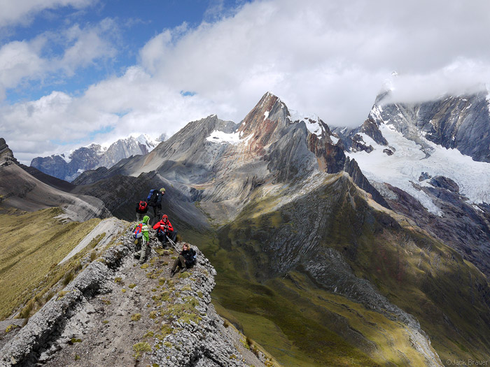
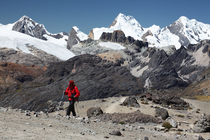
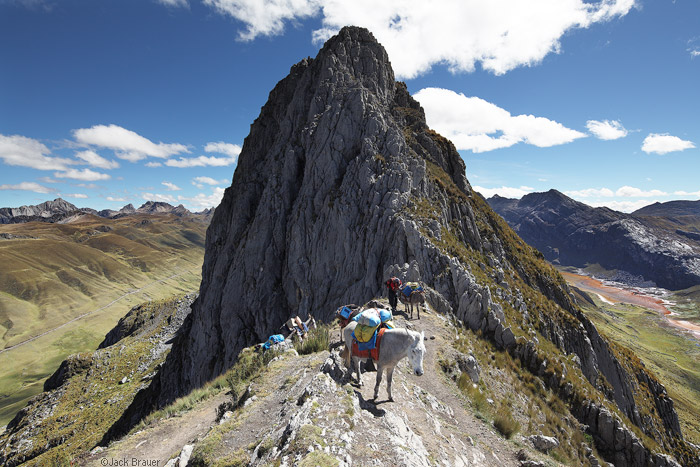
Today we're back in South America, for a different mountainous landscape than we saw earlier with Mt. Roraima: the incredible Cordillera Huayhuash.  This small, 30km range rises through several areas, including the Ancash, Lima, and Huanuco regions.The Huayhuash also encompasses several lakes and peaks over 6,000 m (see the map from SummitPost below).

Peru

Peru

This is not the most popular route through Peru (that would be the busy Inca Trail, which winds up to the ruins of Machu Picchu), this one is certainly more demanding.  Most of the trail is above the treeline (4,000 m), so grasslands and landscapes typical of the paramo dominate, punctuated by lofty peaks. It is dry during the middle of the year, and that is generally considered the best time to go and explore the area. 
  Peru
The area is also noted for its glaciers, which dot the spaces between the mountains and passes, as well as the glacial lakes that are fed from the runoff of the ice. 

Tepuis


From what I've read, the trek takes about 10-14 days, and during that time you are likely not to see another foreign tourist, only local Peruvians that inhabit the few towns you trek through.  The area is generally considered safe these days; the area was once a base for the rebel group Shining Path, and though there have been attacks in the past (1990s and before), the locals have taken security into their own hands.  There is a "security fee" charged in order to help provide them with means, but it seems a small price to pay to be able to trek safely through this region.
Thank you to Jack Brauer and his blog Mountain Photographer, which supplied this destination file with most of the images.  Check out his fantastic collection of images while trekking here.

Peru

Peru Peru

Wednesday, February 8, 2012

Destinations: Mount Roraima

Destinations: Mount Roraima
Guyana, Brazil, Venezuela
5.1433, -60.7625

(Note: this is a new part to this blog... I've been wanting to try and incorporate more of the 'wandering' into A Wandering Lens, talk about places I've been, as well as places I want to go.  This is the first installment of the latter, with images that are not my own since I haven't been there yet.  I hope you enjoy it.)

There are certain places that are simply otherworldly, beyond what you imagine a landscape to be, and Mt. Roraima fits that classification.  It is located in the tepuis, a plateau of blocky landscape in the southeastern portion of Venezuela, and marks the triple point between the countries Guyana, Brazil, and Venezuela.  It is part of the region known as the Gran Sabana, and the tepuis are almost permanently shrouded in mist and clouds, where rainfall is common on a daily basis. And unlike a conventional mountain chain, the tepuis are isolated table mountains that have been thrust up and then resisted the weathering over millions of years, forming these islands jutting into the sky.

Tepuis

This is an area that defies explanation.  First witnessed by Sir Walter Raleigh in the late 16th century, this area wasn't really explored until the 19th century, when explorers made the first hiking ascent of the mountain to the strange top.  The sheer promontory makes climbing exceedingly difficult, and the appearance of the mountain, sticking like a block out of the lush jungle, was reportedly the inspiration for Sir Arthur Conan Doyle's The Lost World.  And, more recently, the team from Pixar used Mt. Roraima for ideas of Carl Fredricksen's destination in the movie Up.
  Tepuis
While Mr. Roraima is the most famous of the tepuis, and the highest (2,772 m), there are certainly others worthy of visiting.  The highest waterfall in the world, Angel Falls (or Salto Angel) falls from Auyan-tepui (2,460m) a 435 square mile heart shaped table mountain first discovered in 1937 by the pilot Jimmie Angel.

Tepuis
This sort of area is so strange, it is no wonder it has inspired books and movies since its exploration by Europeans.  It looks like something created for a video game almost, I could see it as a landscape from Myst back in the day.  While it is fairly barren on top, with little vegetation, the high sheer cliffs provide a base for beautiful, lacy waterfalls that dangle over the side.  The only way to hike it is a long mountain path that was first climbed by Everard Im Thurn, an English Botanist,with Harry Perkins in 1884.  The eponymous route is now the only way to hike to the summit.  Climbing is even more difficult, as the cliffs of Roraima are inverted and very sheer (not to mention the permits and authorizations that go into climbing in a National Park in South America).

Roraima has a haunting quality that just begs to be experienced first-hand.  It doesn't hurt that it is in the middle of the South American jungle either!  But Mt. Roraima is firmly on my list of destinations to see one day, and I wanted to share it with you all.  Enjoy. 

Tepuis Tepuis

Monte Roraima - Proa

Mt. Roraima Mt. Roraima

Tuesday, November 15, 2011

Swirling Vortexes

Swirling Vortexes
ECUA08D-280
January 24, 2008

Still in Ecuador today, we are visiting part of the river system that makes the cloud forests so lush.  This river was torrential, with rain falling even as I hiked past, with lichens, ferns, and mosses dripping from the trees above.  It was such a vibrant scene, the energy and the sound of the river flooding my eyes and my ears as I watched.  It is an incredible place.  Enjoy.

Technical notes:
Camera: Nikon D80
Lens: Sigma 10-20 f/4-5.6
Focal length:  10 mm
Exposure: 1/2.5 @ f/22 ISO 100
Post-processing: Tone, sharpness adjusted in PS 4 and LR 1.4.

Monday, November 14, 2011

The Marshlands of the Paramo

The Marshlands of the Paramo
ECUA08D-520
January 27, 2008

While a lot of the paramo is thought to be dry alpine grasslands, it is quite a diverse and interesting ecosystem.  Today's image to kick off the week is still found in Ecuador, hiking around a shallow seasonal lake and wetlands near Mt. Ruminahui in Cotopaxi National Park.  This shot, I believe, shows off the diversity of the highlands, and also gives a brief glimpse at how beautiful this area is.  Enjoy.

Technical notes:
Camera: Nikon D80
Lens: Sigma 10-20 f/4-5.6
Focal length:  10 mm
Exposure: 1/6 @ f/22 ISO 100
Post-processing: Tone, sharpness adjusted in PS 4 and LR 1.4.

Friday, November 11, 2011

Down that Dark River

Down that Dark River
ECUA08D-169
January 22, 2008

I love rivers.  Always have.  And while many rivers have been tamed in this country (though, luckily, there are some small movements to free rivers from damming in the west), the sight of unbridled water flowing, powerfully coursing through a forest, canyon, or jungle, gets me salivating.  I see scenes like this, and think of reading Heart of Darkness, that high school novel that most people hated, but I loved the descriptions of the water, how the jungle seethed like a living thing as Marlow heads up the Congo in search of Kurtz.  You can see these walls of vegetation on the side of the water, filled with dozens, hundreds of species all vying for nutrients, all trying to eke out an existence, in the most primal, most important battle imaginable.  It is a powerful feeling to be watching this unfold, all to the sound of the beating water.  Enjoy.

Technical notes:
Camera: Nikon D80
Lens: NIkon 18-135 f/3.5-5.6
Focal length:  18 mm
Exposure: 1/6 @ f/22 ISO 200
Post-processing: Tone, sharpness adjusted in PS 4 and LR 1.4.

Thursday, November 10, 2011

Cloud Forest Cascade

Cloud Forest Cascade
ECUA08D-216
January 23, 2008

Serendipity does play a large role in photography, but probably even more important is allowing yourself the freedom to experience it.  I think of this photo, which originated in an early-morning run/hike session through the forest in Ecuador before my workshop began and I was forced to be a professional.  At the end of the trail I came across this small waterfall, which was in as idyllic a setting as imaginable.  After standing a few times to take standard shots, I looked down, and thought how much better it would be if I could give the feeling of the water flowing past you, which was how I perceived it while I was hiking.  So I hunkered down in the water, aiming upwards to capture the rocks at the forefront of the waterfall.  I was pleased at the result, and it won a regional award with my camera club back in Champaign.  But I enjoyed even more the feeling of discovery, the combination of my setting off with no expectations, and then visualizing this image how I wanted to capture it.  That doesn't happen often enough, something I need to work on, but on this morning it all came together for me in this image.  Enjoy.

Technical notes:
Camera: Nikon D80
Lens: Sigma 10-20 f/4.0-5.6
Focal length:  10 mm
Exposure: 15 sec @ f/22 ISO 100
Post-processing: Tone, sharpness adjusted in PS 4 and LR 1.4.

Wednesday, November 9, 2011

Hard Life on the Paramo

Hard Life on the Paramo
ECUA08D-538
January 27, 2008

Above the treeline of Ecuador, far from the tropical jungles and misty cloud forests, there is the paramo.  This alpine ecosystem is a grassland that extends up to the rocky bareness of the mountainsides.  It is beautiful, with the sweeping views between icy peaks, but it also can be a harsh life, as evidenced by this bull, found while hiking along near Mt. Ruminahui in Cotopaxi National Park.  It was a grizzly reminder of how harsh conditions can be out in the wilderness, even in a beautiful and seemingly idyllic setting.

Technical notes:
Camera: Nikon D80
Lens: Sigma 10-20 f/3.5-5.6
Focal length:  10 mm
Exposure: 1/8 @ f/22 ISO 100
Post-processing: Desaturated in LR1.4, tone, sharpness adjusted in PS 4 and LR 1.4.

Tuesday, November 8, 2011

The Misty Jungle

The Misty Jungle
ECUA08D-200
January 22, 2008

Ecuador has been a lot on my mind recently.  It was the place that launched a lot of my current research interests, and gave me a brief glimpse of what ethnobotany and natural products held for me.  It is also my aim to get back there, and I'm working a couple different funding angles to return and explore more of this gorgeous land.  But this shot was looking at the cloud jungles for which Ecuador is partially famous.  These mid-elevation forests blanket the hills before giving way to the paramo (more on that later this week), and yet above (and thus cooler) than the low-elevation jungle to the east, the western edges of the Amazon.  And they are breathtaking to see, in the morning, in the fog of the mist of the rain which is never far away.  Enjoy.

Technical notes:
Camera: Nikon D80
Lens: Nikon 18-135 f?3.5-5.6
Focal length:  18 mm
Exposure: 1/2 @ f/16 ISO 400
Post-processing: Minor tone adjusted with PS 4 and LR 1.4.

Monday, November 7, 2011

Mantis Style

Mantis Style
ECUA08D-287
January 24, 2008

Oh to be in the jungle, where photographs basically leap off branches for your attention.  This week's images come from the archives from Ecuador.  This little guy came crawling close, but didn't stay long enough for a switch to a macro lens.  So I had to do the best with what I had.  He (she?) has these wing like features, make them look like some of the nuns' habits that can be seen, lending even more credence to the term 'praying.'  Enjoy.

Technical notes:
Camera: Nikon D80
Lens: Nikon 18-135 f?3.5-5.6
Focal length:  135 mm
Exposure: 1/60 @ f/5.6 ISO 400
Post-processing: Minor tone adjusted with PS 4 and LR 1.4.

Tuesday, September 20, 2011

Ruminahui Through the Clouds


Ruminahui Through the Clouds
ECUA08D-513
January 27, 2008

While most people travel to Cotopaxi National Park, in Ecuador, to visit the refuge or climb up the eponymous mountain, there are plenty of other reasons to visit this high altitude park. The páramo, or alpine valleys above the tree line, offer a wide diversity of plant life, and from far away it looks like the whole place is covered in a soft velvet. Ruminahui, a dormant volcano found at the edge of the park, is not as visited as the park's namesake, but it is a beautiful climb to the peak, with views over the paramo and the alpine fields. It rises about 4700m above sea level, and is about a 5-6 hour hike from the edge of Laguna de Limpiopuguna.

The mountain's name comes from the early colonial days. Ruminahui was a Quichua native, who lead numerous uprisings against the foreign invaders of his country. He was immensely popular with the people, but not so with the Spanish conquistadors (as can be imagined). Eventually he was captured, as all good folk heroes are, and executed. But this mountain was named in his honor, to remember his struggle for his people against the colonists.  Enjoy.

Technical notes:
Camera: Nikon D80
Lens: Nikon 18-135 f/3.5-5.6
Focal length:  85 mm
Exposure: 1/50 @ f/16, ISO 200
Post-processing: Minor contrast and tone adjustment, sharpening in PS4 & LR1.4